Welcome. A moment-to-moment story...
Showing posts with label Threat: Pollution. Show all posts

Metal scrap collectors clean woods!

Finally.  Abandoned old automobile parts found near a stream were hauled out of the woods.  This message and photo is shared by a friend.

         "I was driving by the other day and saw a pickup truck parked over by the path leading into Spring Pond Woods. I slowed down thinking that it might be someone dumping stuff but I was wrong. I looked down the path and saw two guys struggling to get a really heavy object out of the woods. It was a Chevy straight 6 cylinder engine. They were carting it out on a two wheeled dolly. This thing probably weighed about 5 hundred pounds. They were cleaning up the old rusted stolen cars that had been there for decades.(!) The motivations were partly selfish, as they were looking for scrap metal to trade in for cash. But that was outweighed by the fact that they're doing a really good public service. I haven't been down there this week but will take a look when I get a chance. This saves the city of Peabody a few bucks."


Thank you for sharing, and thank you to the men who picked up the debris.
I believe the skeleton from one of these old vehicles was removed from the woods.  

Letter: Lowe's project will steal the night sky.

Below is a letter to the editor, The Daily Item, Monday Oct. 25, by William Reilly.
Others and I have the same question about the night sky.  Not only are the stars becoming difficult to see, Spring Pond Woods is an important regional wildlife corridor.  It is important to keep these woods dark for the harmony of the wildlife and the community.  This project is already proposing to clear away a habitat, but to light the remaining area at night, is introducing further threat.

On July 15th, in a Salem Planning Board Meeting, open to the public, Lowe's discussed using lighting which will not illuminate the sky (but not on 4' poles), and Walmart discussed nothing about it.  I stood to argue, that the lights in the parking lot will not be illuminating an empty, asphalt parking lot, yet light will be shining down on metallic surfaces, such as glass and metal on vehicles, whereby reflecting light into the sky.  And as vehicles travel up the inclining roadway to reach Lowe's parking lot, the headlights will be shining in the night sky and direction of the forest... and as they travel around in the parking lots.

My question remains.  Even with precautionary lighting to reduce illumination in the sky, it is safe to say, the sky or nearby woods will not be dark, and how much will it be illuminated?

I have a question for you.  Most of your letter highlights several concerns, but it seems there is an argument in the last paragraph, which seems unfinished?  

Good work on raising the question.


peace on

Topo Study of the hills around Spring Pond

          There is concern of having commercial or industrial 'development', especially businesses which have a history of pollution offenses, to be allowed on the hills surrounding Spring Pond, Peabody's Drinking Reservoir.

Lowe's history of offenses
Lowe's was fined a penalty by Mass DEP in April 2010 for polluting groundwater in Pembroke: www.mass.gov/dep/public/press/0410lowe.htm
Lowe's developer penalized by Mass DEP in May 2010 for violation of a wetland: www.mass.gov/dep/public/press/0510lowe.htm
Lowe's fined $137,500 by EPA for failure to adequately control storm water run-off at 4 Mass construction sites: click here


Walmart's history of offenses
MassDEP Assesses $8,000 Penalty to Wal-Mart for Violating Hazardous Waste Management Requirements at Four Central Mass. Stores in May 2010. www.mass.gov/dep/public/press/0510walm.htm


What the reps of Lowe's/ Walmart presented

In the last Public Meeting on September 30, 2010, the reps for the proposed Lowe's/ Walmart refuted environmental concerns by saying there is no record or potential for endangered species and there is no concern of the project related to Spring Pond.  A flat site plan was displayed, showing no topography, with only showing a dimension line from the back of the project to Spring Pond.  There was no indication of Mass DEP Wetlands or the Mass DEP 'Potential Vernal Pools' on the drawing.  There was no mention of the latest Peer Review provided for the project, which mentions concern for Spring Pond.  ( Is this the best the Walmart/ Lowe's reps can do, to represent an environmental study of the site?  Topography and wetlands should not be ignored when researching a study of the site.)


Concerns for Spring Pond
A recent Peer Review warns of the concern, the project might have to Proctor's Brook which flows to Spring Pond.


A precedent environmental mistake in 1996, cost the City of Peabody to clean the sludge from the Coolidge Avenue Water Treatment Plant, which accumulated to the bottom of Spring Pond.


A further  study, by an ordinary citizen...
The 3d model of the site above and the 2d site plan below, was created using data extracted from Mass GIS, in the software program Vectorworks Designer: Architect, Landmark, Renderworks. 

peace on

Wetlands connected to Spring Pond

"A toxic dump in the rear of commercial lots is typical", a local Conservation Commissioner once said.  If this is "typical", how come commercial businesses are allowed near important waterways?

A big Lowe's commercial development is proposed to be constructed uphill from Spring Pond.  How much of an impact on wetlands connecting to Spring Pond, will this project have?  

Studying the history of the waterways, the streams from the hills historically connect to Spring Pond.  A historical map, c1900 shows just this. Today the streams appear to of grown, creating more wetland areas in the hills, with the exception of an old marsh being eliminated where Walmart now stands.  The streams are low or dry now in these drought summer months, to be able to make a determination.  Comparing the stream from the old map to the current map conditions, this gives concern that the proposed Lowe's lot, access road and retention pond is too near uphill from important waterways that potentially connect to Spring Pond.  I hope this raises concern to not repeat the precedent costs from 1996, where the City of Peabody had to pay to clean the sludge from the Coolidge Avenue Water Treatment Plant that accumulated at the bottom of Spring Pond.  Here is a map of the existing wetlands and streams, overlain with the proposed Lowe's/ Super Wal-mart development.
(Map created using the software Vectorworks Designer: Architect/ Landmark/ Renderworks, using data extracted from Mass GIS Oliver, and an image file of proposed development.)

There are many precedent environmental crimes to be concerned about.  Is it safe to say, award winning systems that corporations tout about, will fail again as they have in the recent few months?
Thanks to a few friends for sharing some of this info.
Peace on

History repeats

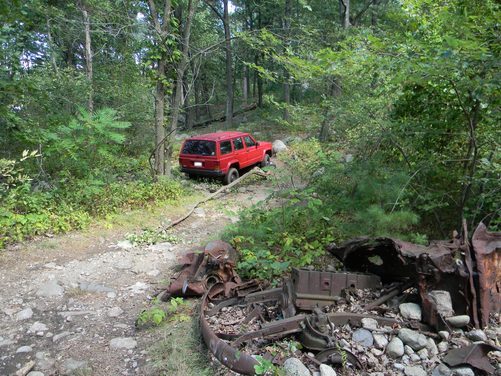
       A friend submitted this photo of a SUV parked on Spring Pond Road last week in Salem, near the other 1940 vehicle dump.  How these automobiles are able to arrive here is amazing.  The road should be blocked around the pond, except for emergency vehicles.  Whoever the criminal is, if stolen or not, they parked over a stream that flows into Spring Pond.  Today, it is good to see the SUV removed, and there seems to be no sludge left from the vehicle on the soil where the brook normally runs through.  Remember, this is not a good path for off-road vehicles.  It's easy to get stuck, caught and a $300.00 fine.


Inconvenient Truths

Update:  Checking the links to the City of Salem website concerning the meetings mentioned below, on September 16, 2010 it is found that the links to the pages have been 'broken' or 'changed'.   This post will be updated soon with the meeting minutes attached.
------------------------------------------------------------------------------------------

How to understand this?
How Salem is dealing with wetlands, in an appearing unrighteous fashion - helping development push through on pristine wooded, non-profit, open-space of camp ground.  5 questions remain.


---------------------------------------------------------------------------------------
    Back on Dec. 11, 2008, in a meeting with the Salem Conservation Commission, Terry Gensel from ENSR/AECOM requested to classify the designation of a wetland as "intermittent rather than perennial so there will be no surprises to the buyer or seller." A site visit was okayed at this request.   (For meeting minutes click here)
  • Q:    Can a waterway be determined by the Commission in one site visit, in a cold month of December for the advantage to the seller or buyer? 
  • A:    No.  According to Mass DEP 310 CMR 10.00: WETLANDS PROTECTION  (click here)  "proving that a stream is perennial by direct observation requires multiple observations made in the late summer and early fall months over many years.."
---------------------------------------------------------------------------------------

    Camp Lion's parcel was rezoned in 2009 by the City of Salem, resulting in giving the development of Lowe's and expanded Super-Walmart a go.  
  • Q:  Was this done illegally as spot zoning? 
  • A:  Hmmm....  From a statement mentioned in the Salem Public Hearing on Sept. 3, 2008, between Salem Council and the Planning Board, it states - "The catalyst for this ordinance amendment was the talk for the development of Camp Lion and Walmart."  (Meeting minutes click here ) 
---------------------------------------------------------------------------------------

     In 2007, Salem proposed an Open Space and Recreation Plan to preserve open space.  In it, Camp Lion is inventoried. It states strategies on how to go about preserving open space like Camp Lion. One of the important things it mentions is to  "Revise local Wetlands Ordinance to include the implementation of conservation restrictions on parcels developed adjacent to resource areas" (Reference on page 99)
  • Q:  Should we ask?:  Was Salem fully aware their local wetland ordinance needed to be updated in order to create more restrictions against development on open space... in 2009 when Salem rezoned Camp Lion's open-space parcel for development?   The Salem Wetlands Ordinance (from the 70's) did not become updated when the zoning was redone for "the catalyst" event.
  • A:  We don't need to ask to know the answer now.

---------------------------------------------------------------------------------------

     In the recent Salem Public Hearing on July 15th, 2010, the Development Group tried to say certain parcels, like Walmart’s lot need not apply for a wetlands special permit, because it was felt the property was not in a wetland/flood hazard district, according to the Salem local wetland maps (from the 70's that were not updated).   A person of the 'public', then commented at the hearing that the development should be following the latest wetlands maps by the DEP instead of the local Salem ones begin followed from the 70's... which does not have as much restrictions.

  • Q:  Is it pretend time and no one told me?

---------------------------------------------------------------------------------------

     Flooding and drainage:   Walmart's parcel is built on an old marsh.  Along with Highland Ave this area floods in a rainstorm. Please refer to the Mass GIS data layer for a historic map of c1900 showing a marsh in this area, or click here to view 3rd pdf.   The drainage system in both Salem and Lynn could not handle the water overflow.

  • Q.  Why isn't this area on the Flood zone layer?  And why is there flooding shown just over the line in Lynn and Peabody, but not in Salem?  Refer to Mass GIS or click here to view 2nd pdf. 
  • A.  Because it was not reported....  because?
---------------------------------------------------------------------------------------

Anymore questions?


To download poster:  For best quality, click to open (zoom in), then right-click to save.


Broken-hearted: broken nestling

Remember this recycled, used asphalt, toxic dump?  uphill from a stream and Spring Pond.  It has been patted down now.  Is the owner aware what their developer has done?
Just look at this cheap poison...


Google earth has a recent image of the clearing. (click map below to view).  If the clearing from the photo looks big, imagine nearly half of the front property of Camp Lion being cleared and blasted.  How many trees and nature's gems will be lost?

It is wrong the local paper wrote with complete ignorance, that this green gem is just a vacant lot...

Taking a closer look at the clearing in the rear, walking through with Leslie and Brian, on the edge of the clearing we noticed cut downed trees. Underneath one dead tree, there area few different type of hawks' feathers, near what appears to be a large bird's nest.  There were two young nestling Red-tailed Hawk feathers near to what we believe was a large nest.   I'm no expert, but the little feathers seem like the young who had them- could not fly.  Is it wrong to question if there was a hawk's nest here?  I hope if their was wildlife, it escaped before the ax came in.


We keep finding hawk feathers on the trails here.
Could there possibly be other large nests, in the area planned for destruction?  We found a few smaller nests, but it is hard to see if there are any big ones high up above the dense forest.  I hope this raises concern to investigate the area.  
I hope the owners are aware what has been done here.  

tear down paradise to put up a parking lot?
"vacant land", huh?

Apologies, but yesterday's walk was heart breaking.


1940's vehicle

If anyone is looking for a 1940's vehicle motor or parts, please feel free to come collect this from the site on Spring Pond Road, Salem side.

peace

Letters to the Editor: Big Box, Cellular, etc.

Here's a bit written as a Letter to the Editor in the Lynn Item....
 
Now, who said the people of the Fay Estate do not have a cell phone tower monstrosity to deal with?   Camp Lion of 181 Fays Ave, Lynn/ Salem has one. (see this)   Coincidentally, this letter to the editor endures the same manic writing as this blogger.


Here is a response from a resident, in Letters to the Editor, of the Lynn Item...


Here is an indirect response....


Please send your Letters to the Editor. 
Your writings could help save these woods, wetlands, neighborhoods, history, traffic problems, existing businesses, etc., etc...

Salem Gazette: salem@cnc.com
Lynn Item: 
letterstoeditor@itemlive.com
Lynn Happens: 
editor@lynnhappens.com
Lynn Journal: editor@lynnjournal.com 
Peabody: 
editor@weeklynews.net
Boston Globe: 
letter@globe.com


Polluter Watch: Dump on Wetlands

     Someone has polluted the wetlands and protected waterway areas on the rear of Walmart's property.  This is not good.  Does anyone know how to contact Walmart to let them know someone polluted on their property in protected areas?

There is asphalt, containers, piles of dead branches, and an area covered by a plastic covering.  I wonder if there is anything under the plastic?


Wetland plantings trying to grow through the dumped asphalt....


Plastic covering over the land...


pile of organic dump...


map of pollution showing approximate area over protected areas...

Would you stick your head in a microwave?... Cell tower at Camp

There is a cell tower on Camp Lion property, near a camp ground for children.


Here's a glimpse from approximately 770 meters away of the tower.  Research on cell towers from expert scientists around the world have lead to consider a safe distance from towers to be around 400 meters, and the risk escalates while getting closer.  
Cell phone towers are everywhere, and this is the reality we are forced to live with, but in recent news concerns for the most vulnerable ones with the highest health risk to these towers are children ( Cell Phone Antennas Blammed for Kindergarten Cancer Cases ).


In the map below, is an approximate area showing 400 meters (1,312 feet).  Please note, satellite photos have been known to be off by 10-60 feet.

Here is other news, where Firefighters have banned cell phone towers on fire stations.

"If they are not an appropriate place for fire stations, then they certainly are not appropriate places for our schools, (our CAMPS,) our neighborhoods and our parks! PLEASE CHANGE Your ORDINANCE, AND MAKE IT MORE RESPONSIBLE!"


Here is a map of the cell phone tower on Camp Lion's property.  Map derived from http://www.antennasearch.com  
To locate a cell phone tower near you, follow this link. 


Things to do to protect your home or work: http://www.emwatch.com/EMF%20Protection.htm

More Resources and links: