Welcome. A moment-to-moment story...

A Labor Day to remember

Local leaders set 'Labor Day' plans for the future by planning big-box stores.  The wealthy of big-box stores like Lowe's and Super Wal-mart will help the economy grow?

Here's an interesting study that might change some thought: 
http://www.huffingtonpost.com/robert-reich/the-real-lesson-of-labor-_b_706121.html?ref=fb&src=sp
        "Where have all the economic gains gone?   Mostly to the top. The economists Emmanuel Saez and Thomas Piketty examined tax returns from 1913 to 2008. They discovered an interesting pattern. In the late 1970s, the richest 1 percent of American families took in about 9 percent of the nation's total income; by 2007, the top 1 percent took in 23.5 percent of total income.....    The rich spend a much smaller proportion of their incomes than the rest of us. So when they get a disproportionate share of total income, the economy is robbed of the demand it needs to keep growing and creating jobs.    What's more, the rich don't necessarily invest their earnings and savings in the American economy; they send them anywhere around the globe where they'll summon the highest returns -- sometimes that's here, but often it's the Cayman Islands, China or elsewhere.....   The rich are better off with a smaller percentage of a fast-growing economy than a larger share of an economy that's barely moving. That's the Labor Day lesson we learned decades ago; until we remember it again, we'll be stuck in the Great Recession."


~ peace

Wetlands connected to Spring Pond

"A toxic dump in the rear of commercial lots is typical", a local Conservation Commissioner once said.  If this is "typical", how come commercial businesses are allowed near important waterways?

A big Lowe's commercial development is proposed to be constructed uphill from Spring Pond.  How much of an impact on wetlands connecting to Spring Pond, will this project have?  

Studying the history of the waterways, the streams from the hills historically connect to Spring Pond.  A historical map, c1900 shows just this. Today the streams appear to of grown, creating more wetland areas in the hills, with the exception of an old marsh being eliminated where Walmart now stands.  The streams are low or dry now in these drought summer months, to be able to make a determination.  Comparing the stream from the old map to the current map conditions, this gives concern that the proposed Lowe's lot, access road and retention pond is too near uphill from important waterways that potentially connect to Spring Pond.  I hope this raises concern to not repeat the precedent costs from 1996, where the City of Peabody had to pay to clean the sludge from the Coolidge Avenue Water Treatment Plant that accumulated at the bottom of Spring Pond.  Here is a map of the existing wetlands and streams, overlain with the proposed Lowe's/ Super Wal-mart development.
(Map created using the software Vectorworks Designer: Architect/ Landmark/ Renderworks, using data extracted from Mass GIS Oliver, and an image file of proposed development.)

There are many precedent environmental crimes to be concerned about.  Is it safe to say, award winning systems that corporations tout about, will fail again as they have in the recent few months?
Thanks to a few friends for sharing some of this info.
Peace on

History repeats

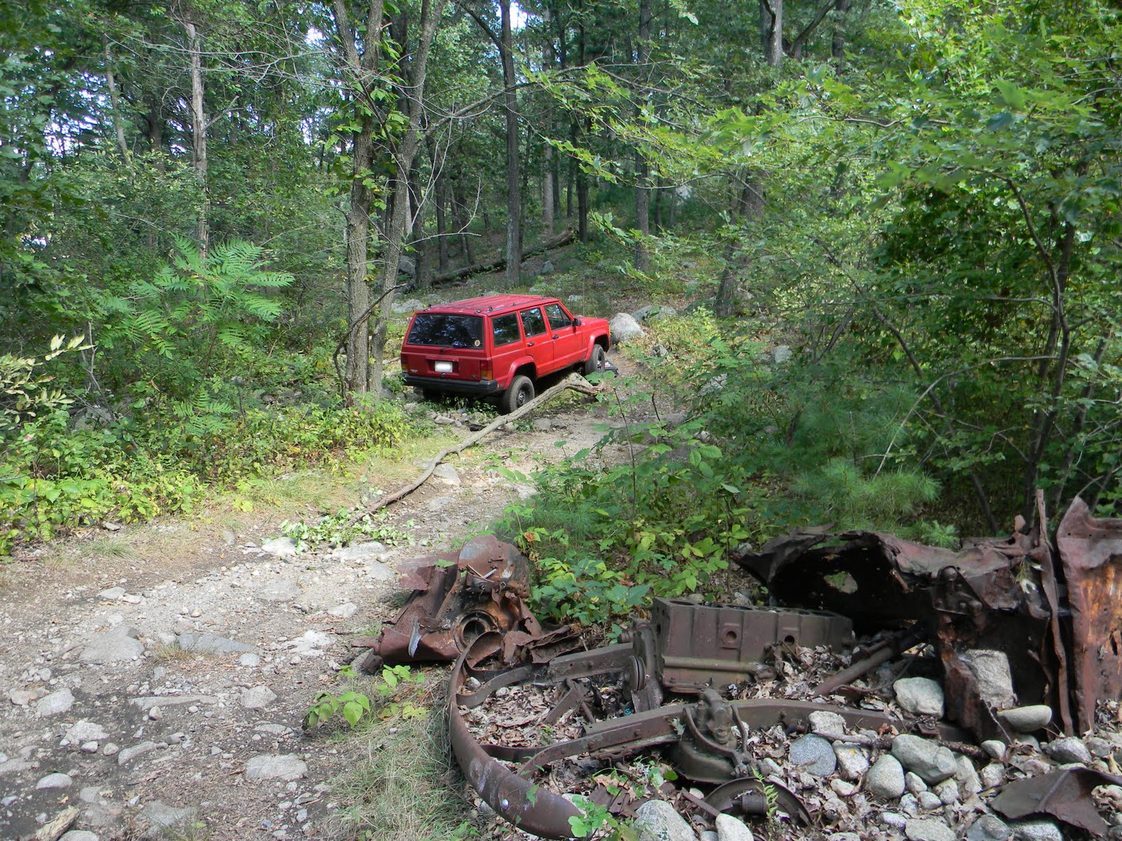
       A friend submitted this photo of a SUV parked on Spring Pond Road last week in Salem, near the other 1940 vehicle dump.  How these automobiles are able to arrive here is amazing.  The road should be blocked around the pond, except for emergency vehicles.  Whoever the criminal is, if stolen or not, they parked over a stream that flows into Spring Pond.  Today, it is good to see the SUV removed, and there seems to be no sludge left from the vehicle on the soil where the brook normally runs through.  Remember, this is not a good path for off-road vehicles.  It's easy to get stuck, caught and a $300.00 fine.


The Fays speak from the grave

       Thank you to Tom Osborne who shared these photos of the tombs of Richard Sullivan Fay and his wife Catherine, where they speak from the grave to SAVE SPRING POND WOODS! Richard Sullivan Fay planted at minimum 200 acres of exotic trees imported from all parts of the world. Today the proposed Lowe's/ Super Wal-mart scheme threatens the forest sprouted by him.
      Washington Irving would of said as he did of his friend, Richard Sullivan Fay...

“He who plants an oak, looks forward to future ages, and plants for prosperity.  Nothing can be less selfish than this (...please remember this the next time people are being called selfish for wanting to preserve community heritage and these woods).  He cannot expect to sit in its shade, nor enjoy its shelter; but he exults in the idea that the acorn which he has buried in the earth grow up into a lofty pile, and shall keep on flourishing and increasing and benefiting mankind, long after he shall have ceased to tread his paternal fields.”


Pine Barren

We can understand from looking at Mass GIS data, there are no records of endangered species sited directly in the Pine Barrens.  However, because a Pine Barren is known to typically have more than a few endangered species thriving in it, how can we be for certain there are no endangered species in this area?  Shouldn't there need to be a full study of the site, on site, to be certain before it is destroyed?  There is one certified vernal pool in the vicinity of connecting wetlands and there are 8 potential vernal pools in abutting wetlands, whereby demonstating the presence of species that are threatened.  The signs of possibility are too high to ignore.


Another question is that an arborist has helped identify unique trees not common in Mass. These trees have been planted here from different parts of the world filling 200 acres and are still thriving. We need to report these uncommon trees that enrich the Pine Barrens and the rest of the region.


A third question is, sightings of hawks and vultures are increasing in these woods year after year. The habitat conditions here of ecological diversity include a mix of dry pine barrens and wetlands on high hill tops and low valleys, with tall trees in unfragmented woodland by a lakelet. We have found a few downy feathers and site of a large nest in the area. Doesn't this increase the importance of saving the largest Pine Barren in Salem?  Pine Barrens offer a unique habitat community, and is severely threatened in Massachusetts by development.  I've also read a Pine Barren helps filter water.  I wonder if it does help filter water before reaching Spring Pond?  


This map shows locations of wetlands, certified and potential vernal pools along the hilly topography... overlain by the proposed threat of a new Lowe's and expanded Super Wal-mart.  As observed, the proposed Lowe's is siting over a wetland marked having a potential vernal pool, and the access road and basins are too near (if not over) wetlands and surface water protection areas.
This map was created in the software Vectorworks Designer: Architect/ Landmark/ Renderworks, using data extracted from Mass GIS, and an overlay of the proposed 'development'.  For analysis of the existing conditions of the site see OLIVER, Mass GIS.


Previous post:   Walking through a Pine Barren


Peace on

In the News... Letter to the Editor

A Letter to the Editor published in The Salem Gazette, The Salem News, and in Lynn Happens.


Letter Headlines: 

Lowe's project contradicts Salem's own open space plan...


Salem should preserve nature by opposing 'big box' project...


"Why Salem leaves behind nature’s open space on the hilly summit by Spring Pond, for big-box development is unknown. A great vision written in “The City of Salem Open Space and Recreation Plan Update: 2007-2012″ strategizes how to conserve important private, open space like this for people."   Read more here on Lynn Happens...  or here on The Salem News or here on The Salem Gazette

----------


(By the way- 4 acres was once part of Camp Lion's open space, and is now Salem's Public Parcel (by eminent domain)... proposed for big-box development.  Not all of the land is currently private.)